Highway 224 & the Upper Clackamas River - Part 5
- Tina McLain
- Aug 18, 2025
- 8 min read

A break down of all viewpoints, river access points, seasonal waterfalls, and hikes along the Clackamas River from Angel Falls to Hole-in-the-Wall Boat Access Site.

Part 5 explores one day use site, two hikes, two views, three pull-offs, two waterfalls, and one pretty section of the river. All of this section is located within national forest.
For more information on activity ideas, resources, safety, and a list of each place by category check out my Highway 224 & Upper Clackamas River - Overview post.
Recreating in Burned Areas
The majority of the Upper Clackamas River was affected by the 2020 fires. Large amounts of the area have reopened as of 2025. There are still a few areas/roads that are closed to public access.
As I’ve noted above, the majority of the Upper Clackamas River was affected by the 2020 fires. Large amounts of the area have reopened as of 2025. There are still a few areas/roads that are closed to public access.
As with any aspect of recreating outdoors, it’s important to make sure what you’re doing is legally open to the public. For up-to-date information on what is open, check out the Mount Hood National Forest website.
Another important aspect to consider when recreating in burned areas is the additional hazards and risks, such as unstable slopes/ground, flash floods, potential for falling trees/limbs, etc.
I really encourage everyone to check out the forest service page, “Safety in Burned Areas,” which discusses how to stay safe in burned areas.
Seasonal Waterfalls Disclaimer
I designate “waterfall” as any amount of water that flows or drops a vertical (or mostly vertical) rock surface. I use the word waterfall rather loosely, and I don’t use any official parameters for what is designated a “waterfall.” Basically if it appears to be falling water, I label it as a “waterfall” for ease of use.
There are a plethora of seasonal waterfalls along the upper Clackamas River. There's no way I could note all of them. So, I'm going to focus on marking those that are 1) most visible from along Highway 224, and 2) the most noticeable/my favorite ones. There are still plenty that I haven’t noted in this post. There are two that I know of that I didn’t add due to it not really being possible to photograph them. So, keep your eyes peeled for waterfalls along the way.
Some are best seen driving a particular direction (east vs. west), so I'll make sure to note which direction has the best visibility when discussing the waterfalls.
Winter/spring is usually the best time to see the waterfalls, particularly after some consistent/heavy rain. There is no guarantee the waterfalls listed will be present at different days/times of year. For the most luck in seeing waterfalls, it’s best to go after there’s been some heavy/prolonged rain along with snow melt.
All seasonal waterfalls are approximate coordinates, it gives the idea of where the waterfall is, but there is room for error on my part.
Pull-offs Disclaimer
I note a majority of the pull-offs along Highway 224, but there are some I’m sure I didn’t cover. It’s as close to being comprehensive as I could get. There is some subjectivity involved as to what constitutes a “pull-off.” So there are some areas others might consider pull-offs that I didn’t note.
There are some pull-offs that have boot paths leading to the river or river views, which I do my best to mention. Most of the photos I took are of the pull-off’s themselves since it is easier to eye that if you go driving yourself. Some places I included pictures of the river, but not in all. I think part of the fun with this list is going to those coordinates and seeing for yourself what it looks like.
Explore the map below to see where each place discussed is located.
Quick Reference

Carter Bridge Day Use/Picnic Site
Coordinates: 45.16786, -122.15762
Use: River access
Activity: Picnicking, fishing, swimming, whitewater rafting, etc.
River (access, view, none): Access
Facilities: Bathroom (looked questionable from a distance)
Parking: There is space for some cars, it isn't as large the pull-off on the SW side of the river, on the other side of Carter Bridge.
Fee: According to the Forest Service website, it is currently marked as temporarily free
Managed By: PGE
Resources: Forest Service
Note: Northwest of Carter Bridge
Easiest driving direction for access: East (towards Ripplebrook), but could be accessed driving either direction.
This day use area is located on the NW side of Carter Bridge. It's across from the currently closed Carter Bridge Campground. This day use area was affected by the 2020 fires. There is a bathroom and sign where fees are collected when being enforced.
According to the Forest Service website this day use are is currently free. When I stopped there was no sign stating the name of the site, I had to look it up online to figure out it's name. It appears to be a lesser-used site, especially during the winter months.

Carter Bridge
Coordinates: 45.16689, -122.15581
River (access, view, none): View
Carter Bridge is the first bridge on Highway 224 when driving east towards Ripplebrook. There are multiple pull-offs and day-use sites near the bridge. I will note that fishing and jumping from the bridge aren't allowed. It is near a prominent white water section of river. It's in this area that the annual Upper Clackamas Whitewater Festival takes place.
Pull-off 45.16617, -122.15532
Coordinates: 45.16617, -122.15532
Use: River access
Activity: Picnicking, fishing, swimming, whitewater rafting, etc.
River (access, view, none): Access & view
Facilities: None
Parking: This pull-off is rather large with huge rocks lining where cars should stop driving.
Fee: None
Note: Southwest of Carter Bridge, across from the whitewater information site
Easiest driving direction for access: East (towards Ripplebrook), but could be accessed driving either direction.
This pull-off is the largest of the ones near Carter Bridge. It's on the SW side of the bridge, on the west side of the road. It sometimes has been a place where people have dispersed camp (illegally since dispersed camping isn't allowed within the Clackamas River Corridor). This pullout can appear a little more trashy than some of the other pull-offs nearby, but it is huge and has room for lots of cars.

White Water Information Site
Coordinates: 45.16611, -122.15468
Use: View of white water rapids
Activity: Hike
River (access, view, none): View
Facilities: None
Parking: The left side of the pull-off is for parking and can fit 3-4 cars. The right side is a no parking zone.
Fee: None
Managed By: PGE
Note: The small little loop trail is only 365 ft round trip
Easiest driving direction for access: It’s easiest accessed when driving west towards Estacada, but can be accessed when driving east.

White water information site is a pull-off site on the east side of highway 225 just past Carter Bridge. There’s a path that leads down to a view of Carter Falls, on the Clackamas River. There are some informational signs. It’s a short viewpoint trail and not just a boot path. The rapids (Carter Falls) is really beautiful and totally worth the stop in my opinion.

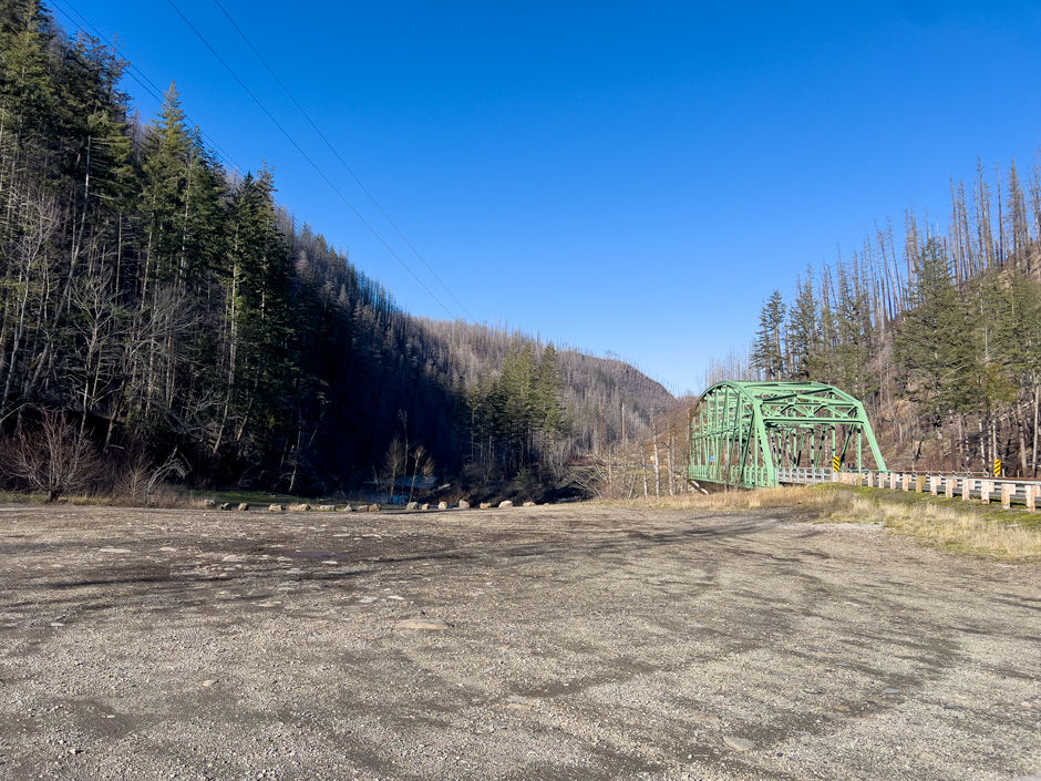
Armstrong Bridge
Coordinates: 45.16215, -122.15128
River (access, view, none): View
Note: Took photo from campground (north) end of bridge.
There aren't really any great places to stop to look at bridge, more a place to see while driving by/over. Probably easier to stop and look at from fish creek road end, than the Armstrong Campground side that I stopped to take. the picture from.

CLOSED INDEFINITELY - Clackamas River Trail #715
The whole trail is within extensive landslide zones and is not safe for public access still in 2025.
Forest Service: "CLOSED due to extensive damage, destroyed bridges, and slide areas from the Riverside Fire. Please do not attempt to use this trail. Staff and partners are working hard to make repairs."

Pull-off 45.16657, -122.13774
Coordinates: 45.16657, -122.13774
Use: View of river and sitting in car.
River (access, view, none): View
Facilities: None
Parking: Space for 10 cars to parallel park along the shoulder of the highway.
Fee: None
Easiest driving direction for access: East (towards Ripplebrook)
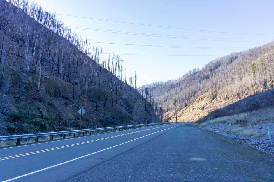
This pull-off is on the south side of highway 224 between Armstrong bridge and Hole-in-the-Wall River Access Site. It’s a wide section of shoulder along the road with space for 10 cars to parallel park along the side of the road. It’s right before mile marker 40.
There is a 4 ft berm lining the south side of the pull-off. It walked up on it provides a view of the Clackamas River below. It’s a rather pretty section with a rock cliff on the other side of the river and moss covering the rocky shore on that same side. There is no river access from this pull-off because the slope is too steep and loose leading down to the river.

Waterfall 45.16800, -122.13380
Coordinates (approximate): 45.16800, -122.13380
Seasonal or Year-Round: Seasonal
Visible From: Highway 224
Best Seen Driving: West (towards Estacada)
This waterfall is on the north side of the road and is most easily seen when driving west. There is no place to stop and pull-off for this waterfall, so it can only really be seen when driving by. It's a mix of creek and waterfall. Further back there is a short drop on a rock cliff face.
Pull-off 45.16757, -122.12449
Coordinates: 45.16757, -122.12449
Use: Parking & view of waterfall
River (access, view, none): None
Parking: This pull off has room for numerous cars, just make sure to not park within where the signs say "no parking" due to being a rock fall zone.
Easiest driving direction for access: West (towards Estacada)
This pull-off is a place to stop to see the seasonal waterfall that cascades down the cliffs nearby. It is west of waterfall 45.16731, -122.12363 on the north side of the highway. The pull-off also has a cool view of the no longer functioning Clackamas River Trail. It's possible to see where the trail cuts into the burnt hillside.

Waterfall 45.16731, -122.12363
Coordinates (approximate): 45.16731, -122.12363
Seasonal or Year-Round: Seasonal
Visible From: Highway 224
Best Seen Driving: Can be seen driving both directions
This waterfall mists down the rock cliff on the north side of Highway 224. It's really beautiful during the winter after heavy rain, and it can get icy when it's cold enough. It's one of my favorite waterfalls along highway 224. And its literally right off the side of the highway.
Reference pull-off 45.16757, -122.12449 for a place to park.

Pretty Section
The section between pull-off 45.16657, -122.13774 and Hole-in-the-Wall Boat Access Site is very pretty. The river and mossy rock cliffs lining it are visible most of the drive. It's one of my favorite sections visually of river.
My Wild Adventure is not responsible for your safety, any possible injury, or anything that happens if you choose to follow anything on this website. Maps are not intended to be used for navigational purposes, but to give an overview of the route taken. By going outdoors you are solely responsible to know your strengths and limitations, be aware of current conditions and proceed with the appropriate caution. My Wild Adventure is not responsible for your choices and the outcome. Reference my disclaimer for more information on being responsible outdoors.


